InAsia
Insights and Analysis
This Land Is Our Land: How Drones Can Advance Property Rights in the Philippines
November 7, 2018
The Philippines has a real estate problem. Half the real property in the country—approximately 12 million parcels of land—has no legal title. Like many countries in Asia, the island nation is experiencing rapid urbanization, and a large proportion of these urban residents in particular lack official titles to the plots of land they live on, which have often been informally subdivided.
Without legal proof of ownership, these citizens can’t get loans to make improvements. They can’t pass down their property to their heirs. Classified as “temporary settlers,” residents who may have lived on their parcels for generations can be driven out of their homes with little notice and no compensation.
According to a World Bank survey conducted with the Philippine government in 2017, addressing the nation’s growing informal settlements is a critical step to strengthening land administration and management. Land-management systems and government policies have not kept pace with the growth of urban centers, and this lack of effective policy infrastructure has held the country back from inclusive growth that could create more jobs and reduce poverty.
Beyond its cost in individual well-being, the Philippines’ land-titling problem exerts a significant drag on development more broadly. Restrictions on untitled land prevent agricultural land from being sold, leased, or mortgaged, blocking development and stifling the land market. The constricted market further inhibits investment, employment, and economic growth.
To properly title an untitled parcel of land, applicants must submit a subdivision survey for approval by the government, but a professional survey can itself be the single greatest obstacle for many citizens, making up about 61 percent of the total cost of titling a residential lot. Now, a project by The Asia Foundation and its team of partners has demonstrated a way around this development logjam with the clever deployment of a new survey technology, aerial drones.
The Asia Foundation’s Technology for Property Rights project works with government and the private sector to develop policies that reflect and respond to the challenges of a rapidly urbanizing Philippines. A partnership with the Omidyar Network and the Foundation for Economic Freedom, the project is pursuing both technological solutions and policy reform to improve land administration in the Philippines.

An example of a traditional survey map in Cebu Province, Philippines, and a drone-generated map of the same parcel.
It was Peter Rabley of Omidyar Network who first suggested that unmanned aerial systems—drones—could be a cost-effective tool for land surveying. Tapping into an emerging movement in the developing world, this Philippines pilot project would join Rwanda, Kenya, and Ethiopia in testing the use of drones for land administration. Working with scientists and policymakers from the Geodetic Surveys Division of the Department of Environment and Natural Resources (DENR)—the Philippines’ national land-management agency—Technology for Property Rights initiated a series of tests to establish the capabilities of survey drones. Additional partners included U.S.-based Micro Aerial Projects, a pioneer in the Drones for Surveying movement; SkyEye Analytics, a leading Philippine drone service provider; and the municipality of Cordova in Cebu Province, where test flights were conducted.
The flights began in 2016. Working with the Technology for Property Rights team, community members and parcel occupants in Cordova volunteered their time to help collect data for maps of their land. Unlike traditional, blueprint-style survey maps, these high-resolution photographic maps gave citizens an intuitive tool to visualize and verify their lots and structures.
The pilot project demonstrated that drones, under the proper conditions, could provide survey data that was just as accurate as traditional methods, meeting or exceeding the Philippines legal standard of 95 percent accuracy. A second round of tests was conducted with the University of the Philippines Department of Geodetic Engineering in 2017 to increase the rigor of the study, this time using various drone types and surveying a mix of different terrains and population densities. Again, the results confirmed that drones could be a highly effective alternative survey tool, leading the Philippine government to become one of the first countries in Asia to issue an official policy allowing the use of drone-assisted surveys for titling.
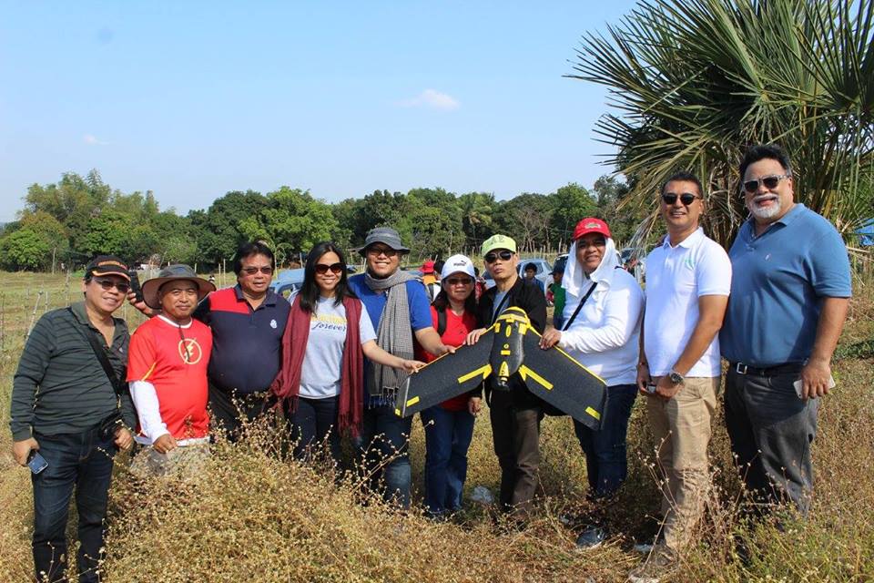
The Asia Foundation’s Jaime Faustino (right) with pioneers in drone-assisted surveying in the Philippines. Photo/The Asia Foundation
The Technology for Property Rights drone-survey team is seeking to reduce the cost of urban subdivision surveys and redress long-standing problems with agricultural land tenure. Already, the project has held training courses on land titling for individuals and organizations, including banks, geodetic engineering firms, civil society organizations, and real estate brokers’ associations, promoting the use of aerial imaging for tenure security and exploring the potential of new, more streamlined administrative systems such as tablet-based title applications. The tablet-based application system will improve on the current, error-prone, manual process and allow DENR staff to easily document claims and monitor the progress of applications. The drone-generated image maps can be smoothly integrated with local government and DENR data to facilitate titling.
Together with a core group of advocates from civil society, academia, and the government, The Asia Foundation is now exploring policy options that would allow government to embrace and integrate the new technologies. With renewed support from Omidyar Network, the next phase of the project will promote other new technologies like mobile applications for land applications, train DENR leadership and geodetic engineers in the use of drones for surveying, and build awareness of the value of drone-assisted surveying, all with the goal of improving the security of property rights in the Philippines and establishing the tradeable and bankable land titles critical for increasing investment and employment.
An easier and simpler land-titling process and reduced land-titling costs will help citizens resolve boundary conflicts and conflicting land claims and ease access to credit by making titled property available as collateral. By forming connections with the public and private sectors and utilizing breakthroughs in technology, innovative collaborations such as Technology for Property Rights can help to tackle multifaceted development challenges, ultimately helping to reduce barriers to well-functioning land markets and encourage greater investment.
Lesley Wynn is a project grants associate for The Asia Foundation’s Resource Development Department in San Francisco. Jaime Faustino is director of The Asia Foundation’s Economic Reform and Development Entrepreneurship Program in the Philippines. He can be reached at [email protected]. The views and opinions expressed here are those of the authors, not those of The Asia Foundation.
1 Comment
About our blog, InAsia
InAsia is posted and distributed every other Wednesday evening, Pacific Time. If you have any questions, please send an email to [email protected].
Contact
For questions about InAsia, or for our cross-post and re-use policy, please send an email to [email protected].The Asia Foundation
465 California St., 9th Floor
San Francisco, CA 94104
The Latest Across Asia

Program Snapshot
April 18, 2024
News
April 17, 2024


2024 Lotus Leadership Awards
Thursday, April 25, 2024, New York City
The Lotus Leadership Awards recognize contributions towards gender equality in Asia and the Pacific
Thanks for the great read. Enjoyed every piece of it!